| |
The equipment is controlled via a specific software for Data Acquisition (GeoTom. It runs on Windows 9x / NT / 2K and XP)
- The external computer (notebook) is connected to the GeoTomMK8E1000 RES/IP/SP either via the RS232 bus, via USB or optionally via a radio transmission device, which ranges 1km at max. with no hindering objects in sight)
- GeoTom allows you to configure and control the complete measurement, select single electrode ranges or perform a surface coupling test to avoid sampling bad data
- All relevant parameters may be altered and configured via menus (Number of stacks, interpolation mode, limits of the standard deviation, electrode geometry and measurement method)
Measuring methods: Wenner, Dipol-Dipol, Pol-Dipol, Pol-Pol, Schlumberger, Wenner-Cylinder, Dipol-Dipol-Cylinder, Wenner-Circle, Dipol-Dipol-Circle, process list, single measurements, etc. (all menu-controlled via GeoTom)
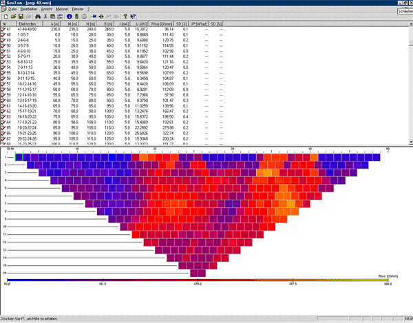
- Display of the most important measuring parameters and results happens in several areas of the screen
- Corresponding settings (chosen electrodes, distances between and position of the electrodes, current, voltage, apparent specific electric resistivity) are listed numerical
- where as the results of the measurement are displayed in a graphical overview (pseudo-section). Thus the quality of the acquired data can be checked in real-time
- The color settings (encoding of the overview) can be adapted to the dynamics of the measured data (linear or logarithmic)
- Results may be deleted, edited or automatically verified through a repeated measurement
- In GeoTom's standard version measured data may be exported or saved as a Listfile or in a format compatible with the 2-dimensional inversion program by M.H. Loke (RES2/3DINV).
- On customer's requirement, other formats can be supported according to individual needs
- During Data Acquisition other completed and saved files may be opened and displayed (and edited) for comparison.
- Features: concise depiction, interactive Data Acquisition, online evaluation of the measured data, context sensitive help
|